Overview
Description
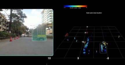
SRIR256-V2 is a real-time 4D imaging radar system. This radar system is based on the SVR4414 high-performance CMOS radar transceiver IC. SRIR256-V2 achieves some of the best-in-class spatial resolutions by cascading four SVR4414 transceivers, each having four independent transmit and four independent receive channels, in a multi-input multi-output configuration (MIMO). This arrangement of 16 Transmit and 16 receiver combinations produces 256 virtual channels which are used to sample both horizontal and vertical space ahead. SRIR256-V2 for LRR mode can combine multiple independent transmit channels in phase to maximize the range. This helps detect targets beyond 250m for long-range applications.
SRIR256-V2 is equipped with state-of-the-art distributed object tracking algorithms based on advanced tracking algorithms and data association. This allows the radar system to track independently moving objects even in crowded environments such as dense traffic. Also, the ego velocity can be computed by the radar for terrain-rich environments allowing the radar to track independent moving objects. radar data from multiple transceivers is sent to an off-the-shelf DSP or GPU which does all the radar signal processing steps including high-density point cloud generation, clustering, tracking, and classification. Renesas provides software to run on ECU units making it power and cost-efficient for customers.
Features
- High density point cloud in 4D space for object dimensions and doppler
- User-configurable detection, clustering, and tracking modes
- Accuracy of 0.1° in azimuth and 0.3° in elevation
- Compatible with popular computing platforms like Nvidia GPU
- Single radar for multiple range modes
- USRR (4GHz), SRR (2GHz), MRR (1GHz) and LRR (250MHz)
- Single radar can be operated in 76-81 GHz
- Real-time point-cloud output
- Based on SVR4414 high-performance CMOS radar IC
- Mapping of both stationary and independent moving targets
- 256 aggregate MIMO channels, 16 transmit and 16 receive channels
- Custom development possibility for azimuth & elevation resolution
- Azimuth and elevation scanning
- Compact size of 19.5cm X 10.8cm X 4.48cm
Comparison
Applications
- Object tracking
Design & Development
Models
ECAD Models
Schematic symbols, PCB footprints, and 3D CAD models from SamacSys can be found by clicking on products in the Product Options table. If a symbol or model isn't available, it can be requested directly from the website.

Product Options
Applied Filters:
